
Fairground Park and Neighborhood has a wealth of history. The Missouri History Museum has the free admision #1 in Civil RIghts The African American Freedom Struggle in St. Louis Exhibition March 11, 2017- April 15, 2018. The exhibition has a display of the Fairground Park Swimming Pool Riot as well as many more historical incidents that occurred in St. Louis. A few highlights of the area are below.
Fairground Hotel Apartment on Natural Bridge Across from park
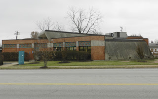
Divoll Library
Grace Hill Settlement House

Beaumont High School
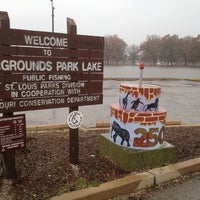
Celebrating 250 year Birthday cake in the park

Area homes
Homes across from the park
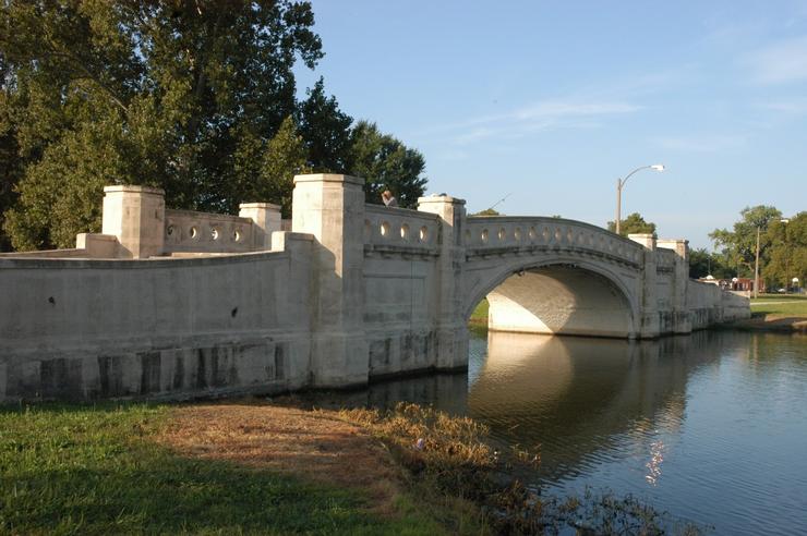
Lake in the park

Skating rink in park
Fairground Park and Neighborhood History
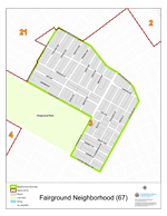
The Fairgrounds neighborhood’s boundaries are defined as Grand Avenue on the East, Emily on the North, Warne on the West, and Fairgrounds park on the South. The Fairground area, stretching westward from Glasgow Avenue to Kingshighway and reaching northward from St. Louis Avenue to its northern boundary along Interstate 70 and Florissant Avenue. Generally, the land has a gradual rise toward the west, with the exception of a valley of a former branch of Gingras Creek, which takes a northeasterly direction through the area’s mid-section
The park is 132-cres that sits in North St Louis at the intersection of north grand and natural bridge. Covering a broad section in the heart of North St. Louis is the Fairground area, stretching westward from Glasgow Avenue to Kingshighway and reaching northward from St. Louis Avenue to its northern boundary along Interstate 70 and Florissant Avenue. Generally, the land has a gradual rise toward the west, with the exception of a valley of a former branch of Gingras Creek, which takes a northeasterly direction through the area’s mid-section.
Most of the area was originally the northern portion of the Grand Prairie Commonfield, composed of a series of narrow eastwest strips laid out by the French for agricultural use. This commonfield portion extended from the present St. Louis Avenue on the south to Carter Avenue on the north and was bordered by Grand Boulevard on the east and by Marcus and Newstead Avenues on the west. Remainder of the areas was comprised of several former land grants designated as surveys. Ownership of both the commonfield strips and the surveys was first held in the name of French colonial land holders. For example, the long strip between Natural Bridge and Ashland Avenues, running westward from Grand, was designated as U.S. Survey #1261 originally owned by Richlet Verdon and later by John Watkins.
Between Grand and Glasgow, was a similar survey, #658, which was acquired by Watkins from Jean Marie Cardenal, and extended northward from present Montgomery Street to Florissant Avenue. North of Natural Bridge and west of Newstead was survey #422, extending beyond Kingshighway and originally owned by Auguste Dodier. A portion of survey #458 was north of this, reaching beyond Florissant Avenue, called the Clamorgan-Brazeau tract.
By 1850, the larger surveys had been subdivided into tracts, then mostly rural, held by many prominent St. Louisans. Jesse Lindell owned one of these which reached along the south side of the Natural Bridge Plank Road from present Glasgow Avenue to Clay Avenue. West of this was the Old Orchard tract, held in the name of Henry Clay, the Kentucky statesman.
The future site of the fairgrounds was the property of Colonel John O’Fallon, and to its west, extending to Euclid Avenue, was the farm of Captain J. M. White. North of this were properties of Elizabeth Hull, Peter Vandeventer, Walker B. Carter, and Henry M. Shreve. Earliest residential subdivision to be platted in the area as White Place, bounded by Natural Bridge, White (now Newstead), Margaretta and Fair Avenues. It was a portion of the J. M. White farm, owned by the well-known riverman, and was platted in 1859. Other early subdivisions were North Cote Brilliante (1861), Lindell’s Additions (1860), Chouteau Place (1875), and James B. Clay’s Subdivision of the Old Orchard Tract (1876).
Sections of the area nearest to the Fairgrounds developed early, beginning in the late 1860s, especially those east of Grand Avenue. Further west, the urban build-up began in the 1880s and was well along by the turn of the century. After 1900, the area south of O’Fallon Park began to develop in such subdivisions as O’Fallon Heights, Plymouth Park and Wanstrath Place. West of Marcus and north of Natural Bridge was a district developed by the 1920s.
One of the last subdivisions in the Fairground area was San Francisco Court, opened in 1957. This area’s relatively rapid development was obviously aided by good transit facilities leading to such area attractions as the old Fairgrounds and the baseball parks in its vicinity.
The history of fairs and exhibitions of agricultural and mechanical subjects in St. Louis began at a very early date. Various fair societies were formed as early as 1822, but none of them was permanent. In November, 1841, a county fair was opened at the St. Louis racecourse at the same time a Mechanics Fair was held in buildings on Fourth Street in front of the Planters’ House. Combination of these interests for the purpose of holding annual fairs was agitated for some years, culminating in the incorporation of the St. Louis Agricultural and Mechanical Association on December 7, 1855. Leader of the fair movement was Colonel J. Richard Barrett, a local member of the state legislature, aided by civic figures such as John O’Fallon, Andrew Christy, Thornton Grimsley, John Withnell, and Gerard B. Allen. Stock in the venture was not intended to pay dividends and profits were used to expand and beautify the enterprise. After a full subscription of stock was achieved, a board of directors was elected in May, 1856.
It was decided to hold a fair in the following autumn and a site of 50 acres at the northwest corner of Grand Avenue and the Natural Bridge Plank Road was purchased from Colonel John O’Fallon for $50,000. This site was chosen due to its proximity to the water works, thereby providing an adequate supply for fountains and other needs. A nine foot fence was erected around the site and construction was pushed so that the fair was opened on October 13, 1856. Principal fair buildings then were an amphitheater, mechanics building, floral hall, machine shop, and livestock stalls. The fair was a success, with succeeding ones increasing in scope, gate receipts and premium prizes. In September, 1860, prior to the opening of that year’s fair, 150,000 persons jammed the grounds to see the Prince of Wales, who later became King Edward VII of England. It was said that a rather tipsy Miasouri governor, Robert M. Stewart, slapped the Prince upon the back and inquired, “What do you think of all this, Prince? Now don’t you wish you were Governor of Missouri?”
The fair of 1860 was the last to be held before the Civil war, during which the fairgrounds and buildings were requisitioned by the army as Benton Barracks, a training area and hospital for federal troops. Fairs were resumed in 1866 and soon exceeded their predecessors in size and attendance. In 1870 a new, larger amphitheater was constructed and used for horse shows and sulky racing. The old one was converted into a display area for manufactured goods and textiles, until it was razed in 1876. In 1874, when Julius S. Walsh was elected as president of the fair, excepting Fair Week, the grounds were thrown open to the public for daily use as a park.
By that time, the grounds had expanded into an area of 83 acres and several new buildings were erected under Walsh’s regime. These included an Art Gallery, Natural History museum and the Zoological Gardens. The Zoo was very comprehensive for its day and included separate buildings for the display of birds, monkeys, deer, bears, reptiles, as well as paddocks for outdoor animal exhibits. The bearpits structure is all that now remains of the once famous Fair. A large Mechanical Hall was opened in 1876, being the largest building on the grounds, with dimensions of 150 by 250 feet. Another development was an art school in conjunction with the gallery. During its prime in the late 1870s, the St. Louis Fair had an international reputation combining the features of an agricultural fair with a metropolitan display. No other city in America could boast of such an annual spectacle during those times. Between 1856 and 1883, more than one million dollars had been spent on improvements and buildings at the Fair and in the latter year average daily attendance was 40,000 and $50,000 was distributed in premium awards.
After the mid-eighties, the Fair began to lose some of its previous public popularity when emphasis was placed upon horse racing. This started in 1883, when the Jockey Club was organized with racing on an old half mile track. In 1885, a new mile track was opened, with a grandstand seating 15,000 and an elaborate new club building. The racing attracted a different class of people, totally unlike the family groups which had hitherto patronized the Fair.
Another factor in the Fair’s decline was the opening of the Exposition Building downtown, on the present site of the Public Library, in 1884. The Exposition, which was open for 40 days each fall, presenting the novelty of a large indoor exhibit was so convenient that many of the Fair’s patrons visited it instead. In addition to the Exposition, the Fair had generated the Fall Festivities during the 1870s. Among features of the Festivities were elaborate street illuminations, begun in 1870 and the Veiled Prophet Parade and Ball, which started in 1878. By 1900, when the Fair had flourished for more than four decades, the citizenry decided that St. Louis had outgrown an agricultural exhibition. Last of the Fairs was held in 1902 when auto racing was tried as an innovation on the race track. By that time, the Fair was forgotten in the midst of preparations for the World’s Fair of 1904. A further deterrent to later revival of the Fair was the banishing of horse racing in Missouri in 1905. The Exposition Building was razed in 1907 and only the Veiled Prophet remains from the old Fall Festivities.
After the demise of the St. Louis Fair in 1902, its 132 acre grounds, buildings and race tracks (after 1905) laid in abandonment until 1908 when the City purchased it for park use for $700,000. Fairground Park was dedicated in 1909 with appropriate ceremonies after the Fair’s structures had been removed. About 1912, the former location of the circular amphitheater was rebuilt into what was then the world’s largest swimming pool, with an area of five acres.
This was a rather prosaic ending to the Fairgrounds which had hosted Presidents Grant, Cleveland, and Harrison and had attracted over 80,000 persons on its featured Big Thursday of Fair Week for many years. This was so, because that day was declared a municipal holiday in 1856, and was looked forward to by generations of school children. Long remembered was that occasion in 1859, when it rained steadily for twenty hours and thousands of women and children were marooned on the grounds until the next day. Another notable event in the park’s history occurred in October, 1911, when the first air mail in the world was flown there from Kinloch. Fairground Park was considerably improved as a result of the 1955 bond issue which provided lighted ball diamonds, hard surface tennis courts and a rebuilt swimming pool with a new field house. Today, the park continues to function as the outstanding north side recreation area that it has been for so many years.
As in many other neighborhoods, streets in the Fairground area memorialize early land owners. Prominent among such streets are Marcus and Shreve Avenues. The former is named after Marcus A. Wolff, who owned property in Cote Brilliante suburb. Henry Miller Shreve, the well-known riverman and Steamboat estate in this section. His neighbor, Walker R. Carter, is similarly honored with a street name. The Fairground area is bisected by its principal thoroughfare, Natural Bridge Avenue, named for a stone arch over nearby Rocky Branch Creek. Some of the original early French landholders are commemorated by present day street names. Among them are Hebert Street, named after the Widow Hebert, whose husband was killed in the Indian attack on St. Louis in 1780.
Others are streets named for Sylvester Labadie and Auguste Dodier. Later land owners of English, Irish and German descent are represented by streets named after William L. Glasgow, Clement B. Penrose, Peter L. Vandeventer, Elizabeth Hull and James B. Clay. Clay, the son of the statesman, Henry Clay, named two streets in his subdivision after Ashland, the family home in Kentucky, and Lexington, his home town. John and Gano Avenues were titled with the given names of J. G. Bryan, whose surname at one time graced a part of Prairie Avenue. Around Fairground Park is Kossuth Avenue, for the Hungarian patriot and Fair Avenue, so-called as the western edge of the old fairgrounds. Athlone Avenue is named for the ancestral Irish home of the father of Colonel John O’Fallon and nearby Holly and Red Bud Avenues also indicate his floral preference. In the area to the east of Fairground Park, streets such as Barrett, Bailey and Peck commemorate early landholders in that section.
Before 1876, when the area west of the Fairgrounds became a part of the City of St. Louis, only one public school existed within that large district. This was the Ashland School at Florence and White Avenues, now San Francisco and Newstead. It was listed by the Board of Education as being on Bridgeton Road one mile west of Grand Avenue and was a three story brick building of six rooms with a capacity of 360 pupils. Apparently built about 1870 by the, then, suburban school district, it served its area until the present Ashland School at 3921 Newstead was opened on the same in 1909.
Two schools were opened within the Fairground area during the nineties. These were the Benjamin Harrison School at 4163 Green Lea Place in 1896, with additions in 1899 and 1905, and the William G. Eliot School at 4242 Grove Street in 1895. Architects for the Harrison building were Kirchner and Kirchner and for Eliot, William B. Ittner.
Increasing enrollment at Central High School at the turn of the century made necessary the construction of two additional secondary schools. These were McKinley and Yeatman, the latter on the north side at Garrison and Natural Bridge. James E. Yeatman High School, named for the St. Louis philanthropist, was opened in September, 1904. It served as the only north side high school until it was replaced by Beaumont in 1926, then becoming an intermediate school, until Central High moved into it in late 1927 after destruction of Central’s old building by the tornado of September 29, 1927. Central has continued to occupy the old Yeatman building since that time.
William Beaumont High School, namesake of the early St. Louis surgeon, was opened at 3836 Natural Bridge Avenue in January, 1926. It had a capacity of 3500 students and was erected at a cost of more than $1,500,000, from plans by architect R. M. Milligan.
The Divoll Branch public library occupied a new building at 4234 North Grand Boulevard in 1966 after relocating from their former structure in the Hyde Park area.
North of Fairground Park is a older neighborhood, mostly built 1890’s and before 1920. Many are two and four family flats, some single family dwellings, the houses built of brick with some frame structures.
There is a concentration of commercial uses along Grand Boulevard northward from St. Louis Avenue to Natural Bridge and again north for Kossuth to Florissant.
The former Fairgrounds Hotel at Natural Bridge and Spring Avenue has been converted into a home for the aged.
In the north sector of the area there is considerable commercial development along West Florissant Avenue from Grand to beyond Warne Avenue and smaller centers, such as the one at Newstead and Penrose Avenues, within the area, Development of the commercial uses took place simultaneously with the residential neighborhoods, both being dependent upon accessibility of public transit.
Transit service was developed quite intensively at an early date in the eastern part of this area because of traffic generators such as the Fairgrounds and the baseball parks. During the late 1850s, horse drawn omnibuses were used to transport the crowds to the Fair and these were superseded by horse cars on rails about 1860.
Principal routes from the city center to the Fairgrounds were lines on Franklin Avenue or on Olive Street with a transfer to a branch line on North Grand Avenue. When the fairs were resumed after the Civil War, direct service to the grounds became available on the Citizens Railway and on the Union Depot Railroad line. On the Citizens line from Fourth Street and Franklin Avenue, it required 35 minutes to reach the southeast gate at the Fairgrounds. The fare was seven cents straight or five tickets for a quarter. Horse cars continued to be the mode of public transit to the Fairground area until the early 1890’s when electric trolley cars were introduced. This development led to the construction of electric lines on both old and new routes. Among those built then were the Grand, Vandeventer, Sarah, Taylor, Natural Bridge, Cass, Lee and Bellefontaine lines, all of which served various parts of the area.
After the closing of the Fair in 1902, traffic generated by the ball parks and newly opened theaters helped the Grand and Vandeventer lines, while the others benefited from concurrent residential construction.
The street railway network was not extended beyond its mileage peak of 1910. Increased service to the Fairground area, as well as to other parts of the City, was provided by motorbus lines in the 1930s. Some of this service paralleled streetcar tracks as by the People’s Motorbus Company’s North Grand line and to some extent by their Walnut Park line on Florissant Avenue. A bus line operated by a subsidiary of the United Railways ran through the western part of this area on Bircher, Shreve and Natural Bridge Avenues. Present day service is solely by motorbus, as the area’s streetcar lines were abandoned bv the 1950s.
Benton Barracks was a Union Army military encampment, established during the American Civil War, in St. Louis, Missouri, at the present site of the St. Louis Fairground Park. Before the Civil War, the site was owned and used by the St. Louis Agricultural and Mechanical Association, which at the time was located on the outskirts of St. Louis. The barracks was used primarily as a training facility for Union soldiers attached to the Western Division of the Union Army.
After the Battle of Lexington, the Post and Convalescent Hospitals were added to the training barracks, in order to assist in treating hundreds of incoming wounded troops. Once the war ended, the barracks was dismantled, returning to its pre-war, civilian use as a fairground and race track. Nothing of the original barracks remains at this site today.
In 1861, Major-General John C. Fremontt assumed command of the Western Department of War for the Union Army. General Fremont ordered the establishment of a training barracks at the site of the St. Louis Fairgrounds. The barracks originally consisted of five buildings, 740 ft. in length and 40 ft. in width. Additionally, there was a two-story building erected for the headquarters of the Barracks Commander. The barracks could accommodate up to 30,000 soldiers. By 1863, Benton contained over a mile of barracks, as well as warehouses, cavalry stables, parade grounds, and a large military hospital. The hospital was built from the converted amphitheater on the fairground site and could accommodate 2,000 to 3,000 soldiers at a time. During the Civil War, under the administration of Emily Elizabeth Parsons, it was the largest hospital in the West. Parsons recorded many of her experiences at Benton Barracks in her memoir.
Before St. Louis was nationally and internationally recognized for Forest Park and the 1904 Louisiana Purchase Exposition, the city hosted the annual Agricultural and Mechanical Fair (1856-1902), drawing crowds from around the country. The 132-acre Fairground Park is situated in north St. Louis at the intersection of North Grand Boulevard and Natural Bridge Avenue.The land that is now Fairground Park was the site of this fair for half a century.
The old fairgrounds included exhibition halls, a racetrack and jockey club, and the largest amphitheater in the country at the time it was built. In 1876, St. Louis’s first zoological garden was constructed on the fairgrounds of the Agricultural and Mechanical Fair. The city’s original zoo included a monkey house, a carnivore house, and a bear pit, among other attractions.[1] In the space that is now Fairground Park, St. Louis established itself as one of the country’s preeminent cities.
In 1908, six years after the last fair was held on these fairgrounds, the city purchased the land for use as a public park. The renowned landscape architect, and the designer of the grounds for the Louisiana Purchase Exposition, George Kessler, was responsible for the design of Fairground Park. While most of the fair’s structures were removed, the façade of the bear pit from the city’s original zoo remained as part of Kessler’s park design. Despite the dismantling of the old zoological garden’s structures, between 1910 and 1913, Fairground Park was considered as a potential site on which the Zoological Society of St. Louis might have established the Saint Louis Zoo that area residents know and love. Today, the only remnant of the fair and the only reminder of the park’s history as a fairground is the bear pit façade.
The integration of Fairground was short lived the riot forced the mayor to

Earlier Swimming Pool
Swimming Pool Riot
